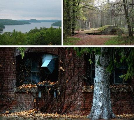
Some nearby structures sit above the waterline but were abandoned without the adjacent buildings that sustained their use. WebUrbanist
Abandoned Flooded City of Quabbin, Massachusetts

The Quabbin Reservoir is the now the largest body of water in Massachusetts. However, the area it now occupies once had four small towns and a network of roads and rail tracks running through it – all of which were flooded or displaced by the filling of the area with water. While some public structures, memorials and graves were moved out of the way many still sit today at the bottom of this body of water. Some nearby structures sit above the waterline but were abandoned without the adjacent buildings that sustained their use.
vía 24 Tales of Ghost Towns and Abandoned Cities Abandoned Flooded City of Quabbin, Massachusetts – WebUrbanist.
Quabbin Reservoir
From Wikipedia, the free encyclopedia
The Quabbin Reservoir is the largest inland body of water in the Commonwealth of Massachusetts and was built between 1930 and 1939. Today along with the Wachusett Reservoir, it is the primary water supply for Boston, some 65 miles to the east, as well as 40 other communities in Greater Boston. It also supplies water to three towns west of the reservoir and acts as backup supply for three others.[1] It has an aggregate capacity of 412 billion U.S. gallons (1.56 km³) and an area of 38.6 square miles (99.9 km²). Quabbin Reservoir water flows to the Wachusett Reservoir using the Quabbin Aqueduct. The Quabbin watershed is managed by the Massachusetts Department of Conservation and Recreation, while the water supply system is operated by the Massachusetts Water Resources Authority. The Winsor Dam and the Goodnough Dike form the reservoir from impoundments of the three branches of the Swift River. The Quabbin Reservoir is part of the Chicopee River Watershed.

Quabbin Reservoir - DCR, USA
Quabbin Reservoir
Quabbin Visitor Center 485 Ware Road (Rte. 9) Belchertown, MA 01007
413-323-7221
Quabbin Reservoir is one of the largest man-made public water supplies in the United States. Created in the 1930s by the construction of two huge earthen dams, the reservoir is fed by the three branches of the Swift River, and seasonally by the Ware River. Quabbin’s water covers 39 square miles, is 18 miles long and has 181 miles of shoreline. When full, Quabbin holds 412 billion gallons of water.
The New Salem and Enfield lookouts offer magnificent views of the reservoir. In order to flood the vast area of the Swift River Valley in the 1930s, the entire population of four towns had to be relocated. Hundreds of homes, businesses, a state highway, a railroad line, and 34 cemeteries were also moved or dismantled. Over 6,000 graves were relocated from the Valley to Quabbin Park cemetery.
Interpretive Services
The Quabbin Interpretive Services Program operates the Quabbin Visitor Center, Education Programs, Teacher Workshops, and provides general information about DCR resources. Three full time staff members are available to assist with visitor information and services. An automated telephone system - 413 323-7221 – provides 24 hour access to current information on fishing, hunting, programs, rules and regulations, and public access.
Quabbin Reservoir logging moratorium placed by Massachusetts Department of Conservation and Recreation
John Appleton, The Republican
BELCHERTOWN – A moratorium has been placed on commercial logging in the woods around Quabbin Reservoir, but about 29 loggers whose current contracts were put on hold will be able to resume work under the terms of their agreements with the state.
The Massachusetts Department of Conservation and Recreationannounced on Tuesday that it is starting a scientific review of its watershed forestry management program, which has included limited commercial logging for more than 50 years.


